
Make a donation
Gear up for your next adventure:
As an Amazon Associate, this site earns from qualifying purchases at no extra cost to you.
Einsiedeln topographic map
Click on the map to display elevation.
Make a donation
Gear up for your next adventure:
As an Amazon Associate, this site earns from qualifying purchases at no extra cost to you.
Einsiedeln
Für die Normalperiode 1991–2020 beträgt die Jahresmitteltemperatur 7,2 °C, wobei im Januar mit −1,5 °C die kältesten und im Juli mit 16,2 °C die wärmsten Monatsmitteltemperaturen gemessen werden. Im Mittel sind hier rund 125 Frosttage und 32 Eistage zu erwarten. Sommertage gibt es im Jahresmittel rund 16, während im Schnitt in zwei von drei Jahren ein Hitzetag zu verzeichnen ist. Die Messstation von MeteoSchweiz liegt auf einer Höhe von 911 m ü. M.
Make a donation
Gear up for your next adventure:
As an Amazon Associate, this site earns from qualifying purchases at no extra cost to you.
About this map
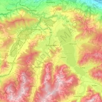
Name: Einsiedeln topographic map, elevation, terrain.
Location: Einsiedeln, Schwyz, 8840, Schweiz (47.06327 8.68420 47.17828 8.88661)
Average elevation: 3,356 ft
Minimum elevation: 1,352 ft
Maximum elevation: 5,217 ft
Make a donation
Gear up for your next adventure:
As an Amazon Associate, this site earns from qualifying purchases at no extra cost to you.
Other topographic maps
Click on a map to view its topography, its elevation and its terrain.