
Make a donation
Gear up for your next adventure:
As an Amazon Associate, this site earns from qualifying purchases at no extra cost to you.
Banepa topographic map
Click on the map to display elevation.
Make a donation
Gear up for your next adventure:
As an Amazon Associate, this site earns from qualifying purchases at no extra cost to you.
About this map
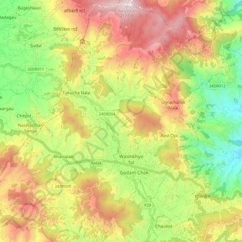
Name: Banepa topographic map, elevation, terrain.
Location: Banepa, Kavrepalanchok, Bagmati Province, Nepal (27.60104 85.46028 27.69437 85.56401)
Average elevation: 5,115 ft
Minimum elevation: 3,399 ft
Maximum elevation: 7,037 ft
Make a donation
Gear up for your next adventure:
As an Amazon Associate, this site earns from qualifying purchases at no extra cost to you.
Other topographic maps
Click on a map to view its topography, its elevation and its terrain.
Nagarkot
Nepal > Bagmati Province > Kavrepalanchok
Nagarkot (Nepali: नगरकोट) is a former Village Development Committee located 32 km east of Kathmandu, Nepal in Bhaktapur District in Bagmati Province and as of 2015 part of Nagarkot Municipality. At the time of the 2011 census it had a population of 4,571 and had 973 houses in it. At an elevation of…
Average elevation: 5,509 ft
Make a donation
Gear up for your next adventure:
As an Amazon Associate, this site earns from qualifying purchases at no extra cost to you.