
Make a donation
Gear up for your next adventure:
As an Amazon Associate, this site earns from qualifying purchases at no extra cost to you.
Lavoir topographic map
Click on the map to display elevation.
Make a donation
Gear up for your next adventure:
As an Amazon Associate, this site earns from qualifying purchases at no extra cost to you.
About this map
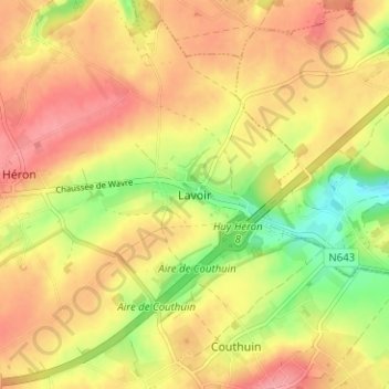
Name: Lavoir topographic map, elevation, terrain.
Location: Lavoir, Héron, Huy, Liège, Wallonie, 4217, Belgique (50.52864 5.10558 50.56864 5.14558)
Average elevation: 538 ft
Minimum elevation: 367 ft
Maximum elevation: 659 ft
Make a donation
Gear up for your next adventure:
As an Amazon Associate, this site earns from qualifying purchases at no extra cost to you.
Other topographic maps
Click on a map to view its topography, its elevation and its terrain.
Hamoir
Le village de Hamoir se trouve essentiellement concentré au fond de la vallée de l'Ourthe à l'endroit de son confluent avec le Néblon ainsi que sur le flanc ouest de la colline, à environ 119 m d’altitude au pont, à 12 km en amont du confluent de l'Ourthe et de l’Amblève, à 39 km de Liège et 24 de…
Average elevation: 699 ft
Make a donation
Gear up for your next adventure:
As an Amazon Associate, this site earns from qualifying purchases at no extra cost to you.
Make a donation
Gear up for your next adventure:
As an Amazon Associate, this site earns from qualifying purchases at no extra cost to you.
Engis
À l'exception du village d'Engis, le territoire communal occupe la rive droite et le versant sud de la Meuse qui fait office de limite avec les communes d'Amay et Saint-Georges-sur-Meuse. La vallée industrielle de la Meuse (sillon Sambre et Meuse) sert aussi d'implantation aux trois principaux villages de la…
Average elevation: 561 ft
Marchin
Bordé à l'est par le Hoyoux, rivière qui conflue avec la Meuse à Huy, Marchin épouse le relief du Condroz fait de tiges et de chavées dont certaines sont arrosées par la Vyle, le Triffoy et le Lileau, tous affluents du Hoyoux. L'altitude varie de 93 à 270 métres
Average elevation: 741 ft
Make a donation
Gear up for your next adventure:
As an Amazon Associate, this site earns from qualifying purchases at no extra cost to you.
Make a donation
Gear up for your next adventure:
As an Amazon Associate, this site earns from qualifying purchases at no extra cost to you.
Make a donation
Gear up for your next adventure:
As an Amazon Associate, this site earns from qualifying purchases at no extra cost to you.
Make a donation
Gear up for your next adventure:
As an Amazon Associate, this site earns from qualifying purchases at no extra cost to you.
Make a donation
Gear up for your next adventure:
As an Amazon Associate, this site earns from qualifying purchases at no extra cost to you.
Make a donation
Gear up for your next adventure:
As an Amazon Associate, this site earns from qualifying purchases at no extra cost to you.
Make a donation
Gear up for your next adventure:
As an Amazon Associate, this site earns from qualifying purchases at no extra cost to you.
Make a donation
Gear up for your next adventure:
As an Amazon Associate, this site earns from qualifying purchases at no extra cost to you.
Make a donation
Gear up for your next adventure:
As an Amazon Associate, this site earns from qualifying purchases at no extra cost to you.
Make a donation
Gear up for your next adventure:
As an Amazon Associate, this site earns from qualifying purchases at no extra cost to you.
Hamoir
Le village de Hamoir se trouve essentiellement concentré au fond de la vallée de l'Ourthe à l'endroit de son confluent avec le Néblon ainsi que sur le flanc ouest de la colline, à environ 119 m d’altitude au pont, à 12 km en amont du confluent de l'Ourthe et de l'Amblève, à 39 km de Liège et 24 de…
Average elevation: 699 ft
Make a donation
Gear up for your next adventure:
As an Amazon Associate, this site earns from qualifying purchases at no extra cost to you.
Marchin
Bordé à l'est par le Hoyoux, rivière qui conflue avec la Meuse à Huy, Marchin épouse le relief du Condroz fait de tiges et de chavées dont certaines sont arrosées par la Vyle, le Triffoy et le Lileau, tous affluents du Hoyoux. L'altitude varie de 93 à 270 métres
Average elevation: 741 ft
Make a donation
Gear up for your next adventure:
As an Amazon Associate, this site earns from qualifying purchases at no extra cost to you.
Hamoir
Le village de Hamoir se trouve essentiellement concentré au fond de la vallée de l'Ourthe à l'endroit de son confluent avec le Néblon ainsi que sur le flanc ouest de la colline, à environ 119 m d’altitude au pont, à 12 km en amont du confluent de l'Ourthe et de l'Amblève, à 39 km de Liège et 24 de…
Average elevation: 699 ft
Make a donation
Gear up for your next adventure:
As an Amazon Associate, this site earns from qualifying purchases at no extra cost to you.
Make a donation
Gear up for your next adventure:
As an Amazon Associate, this site earns from qualifying purchases at no extra cost to you.
Engis
À l'exception du village d'Engis, le territoire communal occupe la rive droite et le versant sud de la Meuse qui fait office de limite avec les communes d'Amay et Saint-Georges-sur-Meuse. La vallée industrielle de la Meuse (sillon Sambre et Meuse) sert aussi d'implantation aux trois principaux villages de la…
Average elevation: 561 ft
Make a donation
Gear up for your next adventure:
As an Amazon Associate, this site earns from qualifying purchases at no extra cost to you.
Make a donation
Gear up for your next adventure:
As an Amazon Associate, this site earns from qualifying purchases at no extra cost to you.
Make a donation
Gear up for your next adventure:
As an Amazon Associate, this site earns from qualifying purchases at no extra cost to you.
Marchin
Bordé à l'est par le Hoyoux, rivière qui conflue avec la Meuse à Huy, Marchin épouse le relief du Condroz fait de tiges et de chavées dont certaines sont arrosées par la Vyle, le Triffoy et le Lileau, tous affluents du Hoyoux. L'altitude varie de 93 à 270 métres
Average elevation: 745 ft