Geolocate

Quibdó topographic map

Click on the map to display elevation.

About this map

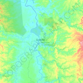
Name: Quibdó topographic map, elevation, terrain.

Location: Quibdó, Atrato, Chocó, Colombia (5.53234 -76.81838 5.85234 -76.49838)

Average elevation: 187 ft

Minimum elevation: 59 ft

Maximum elevation: 627 ft

Gear up for your next adventure:

🛰️Satellite Messengers - Emergency SOS and two-way messaging for off-grid adventures
🥾Women's Hiking Boots - Top-rated trail boots with ankle support and superior grip
🧣Hiking Neck Gaiter - Multi‑use neck protection for outdoor weather
🏔️Mountain Trail Maps - High‑detail maps for popular peaks
🎒Outdoor Daypacks - Lightweight backpacks designed for carrying maps and essential gear

As an Amazon Associate, this site earns from qualifying purchases at no extra cost to you.