
Make a donation
Gear up for your next adventure:
As an Amazon Associate, this site earns from qualifying purchases at no extra cost to you.
Khénifra topographic map
Click on the map to display elevation.
Make a donation
Gear up for your next adventure:
As an Amazon Associate, this site earns from qualifying purchases at no extra cost to you.
Khénifra
Située dans le Dir marocain, perchée à 830 m d’altitude, sur les bords du fleuve Oum Errabia, dans le couloir encombré de coulées basaltiques qui sépare le Moyen Atlas de la Mesata (Plateau Central Marocain), Khénifra se présente comme une cité rouge, reflet de la couleur des sols argileux qui l’entourent.
Make a donation
Gear up for your next adventure:
As an Amazon Associate, this site earns from qualifying purchases at no extra cost to you.
About this map
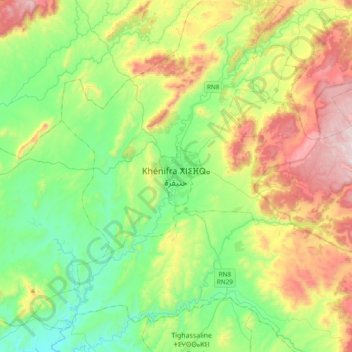
Name: Khénifra topographic map, elevation, terrain.
Average elevation: 3,307 ft
Minimum elevation: 2,201 ft
Maximum elevation: 5,495 ft
Make a donation
Gear up for your next adventure:
As an Amazon Associate, this site earns from qualifying purchases at no extra cost to you.