
Make a donation
Gear up for your next adventure:
As an Amazon Associate, this site earns from qualifying purchases at no extra cost to you.
Hüngsberg topographic map
Click on the map to display elevation.
Make a donation
Gear up for your next adventure:
As an Amazon Associate, this site earns from qualifying purchases at no extra cost to you.
Hüngsberg
Der Weiler Hüngsberg liegt zwei Kilometer östlich des Ortszentrums von Windhagen auf einem nach Osten zum Tal des Pfaffenbachs abfallenden Bergrücken. Die Ortschaft umfasst Höhenlagen zwischen 245 und 260 m ü. NHN. Zu den nächstgelegenen Orten gehören Johannisberg im Nordwesten sowie der Wohnplatz Adamstal im Süden. In Hüngsberg endet die Kreisstraße 30, die nach Windhagen führt.
Make a donation
Gear up for your next adventure:
As an Amazon Associate, this site earns from qualifying purchases at no extra cost to you.
About this map
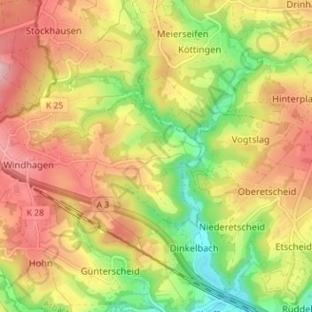
Name: Hüngsberg topographic map, elevation, terrain.
Average elevation: 823 ft
Minimum elevation: 502 ft
Maximum elevation: 1,106 ft
Make a donation
Gear up for your next adventure:
As an Amazon Associate, this site earns from qualifying purchases at no extra cost to you.