Geolocate

Hollis topographic map

Click on the map to display elevation.

About this map

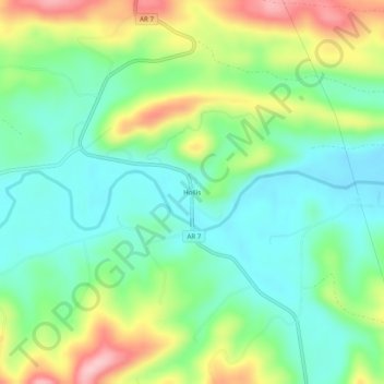
Name: Hollis topographic map, elevation, terrain.

Location: Hollis, Perry County, Arkansas, United States (34.85454 -93.13046 34.89454 -93.09046)

Average elevation: 650 ft

Minimum elevation: 453 ft

Maximum elevation: 1,020 ft

Perry County trails, hiking, mountain biking, running and outdoor activities

Gear up for your next adventure:

🌡️Portable Weather Meter - Track weather conditions on the trail
📦Dry Bags Set - Waterproof storage for electronics and clothes
🧷Carabiner Set - Durable clips for gear attachment
👟Trail Running Shoes - Lightweight shoes for trail runners
🔌Solar Panel Charger - Charge gear sustainably outdoors

As an Amazon Associate, this site earns from qualifying purchases at no extra cost to you.