Geolocate

Nabas topographic map

Click on the map to display elevation.

About this map

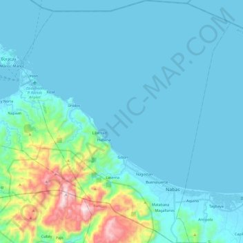
Name: Nabas topographic map, elevation, terrain.

Location: Nabas, Aklan, Western Visayas, Philippines (11.77953 121.95048 12.00110 122.14640)

Average elevation: 233 ft

Minimum elevation: -3 ft

Maximum elevation: 2,828 ft

Other topographic maps

Click on a map to view its topography, its elevation and its terrain.

Agdugayan

Philippines > Aklan > Pandan

Average elevation: 105 ft

Tigayon

Philippines > Aklan > Kalibo > Linabuan Norte > Tigayon

Average elevation: 33 ft

Bagong Barrio

Philippines > Aklan > Makato > Bagong Barrio

Average elevation: 1,024 ft

Andagao

Philippines > Aklan > Kalibo

Average elevation: 23 ft

Lupo

Philippines > Aklan > Altavas > Lupo

Average elevation: 249 ft

Gear up for your next adventure:

📻Weather Alert Radios - Stay informed of storm risks while off-the-grid
🧭Orienteering Set - Complete compass and map reading kit
🦺Reflective Outdoor Gear - Safety gear for low‑light conditions
🔌Solar Panel Charger - Charge gear sustainably outdoors
🎁Geography Themed Gifts - Unique gift ideas for map lovers and geography enthusiasts

As an Amazon Associate, this site earns from qualifying purchases at no extra cost to you.