
Make a donation
Gear up for your next adventure:
As an Amazon Associate, this site earns from qualifying purchases at no extra cost to you.
Old Jefferson topographic map
Click on the map to display elevation.
Make a donation
Gear up for your next adventure:
As an Amazon Associate, this site earns from qualifying purchases at no extra cost to you.
About this map
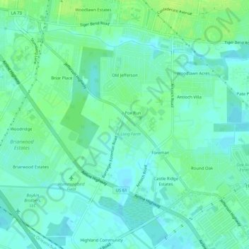
Name: Old Jefferson topographic map, elevation, terrain.
Average elevation: 30 ft
Minimum elevation: 10 ft
Maximum elevation: 52 ft
Make a donation
Gear up for your next adventure:
As an Amazon Associate, this site earns from qualifying purchases at no extra cost to you.
Other topographic maps
Click on a map to view its topography, its elevation and its terrain.
Bell Fontaine
United States > Louisiana > East Baton Rouge Parish > Baton Rouge
Average elevation: 52 ft
Goodwood Homesites
United States > Louisiana > East Baton Rouge Parish > Baton Rouge
Average elevation: 59 ft
Mayfair Park North
United States > Louisiana > East Baton Rouge Parish > Baton Rouge
Average elevation: 39 ft
Make a donation
Gear up for your next adventure:
As an Amazon Associate, this site earns from qualifying purchases at no extra cost to you.
Florida Plaza
United States > Louisiana > East Baton Rouge Parish > Baton Rouge
Average elevation: 62 ft
Sherwood Forest
United States > Louisiana > East Baton Rouge Parish > Baton Rouge
Average elevation: 52 ft
Floyd Place
United States > Louisiana > East Baton Rouge Parish > Baton Rouge
Average elevation: 39 ft
Make a donation
Gear up for your next adventure:
As an Amazon Associate, this site earns from qualifying purchases at no extra cost to you.
Steele Place
United States > Louisiana > East Baton Rouge Parish > Baton Rouge > Steele Place
Average elevation: 56 ft
Tristian Village
United States > Louisiana > East Baton Rouge Parish > Baker > Tristian Village
Average elevation: 82 ft
Highland Farms
United States > Louisiana > East Baton Rouge Parish > Baton Rouge > Highland Farms
Average elevation: 62 ft
Laurens H Cohn Arboretum
United States > Louisiana > East Baton Rouge Parish > Yorkdale
Average elevation: 69 ft
Make a donation
Gear up for your next adventure:
As an Amazon Associate, this site earns from qualifying purchases at no extra cost to you.
Glen Oaks
United States > Louisiana > East Baton Rouge Parish > Baton Rouge > Glen Oaks
Average elevation: 69 ft
Parkview Oaks South
United States > Louisiana > East Baton Rouge Parish > Baton Rouge
Average elevation: 43 ft
Make a donation
Gear up for your next adventure:
As an Amazon Associate, this site earns from qualifying purchases at no extra cost to you.