
Make a donation
Gear up for your next adventure:
As an Amazon Associate, this site earns from qualifying purchases at no extra cost to you.
Emblem topographic map
Click on the map to display elevation.
Make a donation
Gear up for your next adventure:
As an Amazon Associate, this site earns from qualifying purchases at no extra cost to you.
Emblem
Emblem ligt op de overgang van de zandige Kempen en het Scheldebekken p[ een hoogte van 4-13 meter. De zuidgrens wordt gevormd door de Kleine Nete. Parallel daaraan ligt het Netekanaal.
Make a donation
Gear up for your next adventure:
As an Amazon Associate, this site earns from qualifying purchases at no extra cost to you.
About this map
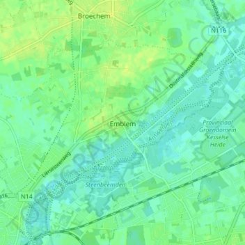
Name: Emblem topographic map, elevation, terrain.
Location: Emblem, Ranst, Antwerpen, Vlaanderen, België (51.14829 4.56484 51.17715 4.63308)
Average elevation: 23 ft
Minimum elevation: 3 ft
Maximum elevation: 46 ft
Make a donation
Gear up for your next adventure:
As an Amazon Associate, this site earns from qualifying purchases at no extra cost to you.
Other topographic maps
Click on a map to view its topography, its elevation and its terrain.