
Make a donation
Gear up for your next adventure:
As an Amazon Associate, this site earns from qualifying purchases at no extra cost to you.
Buissenal topographic map
Click on the map to display elevation.
Make a donation
Gear up for your next adventure:
As an Amazon Associate, this site earns from qualifying purchases at no extra cost to you.
About this map
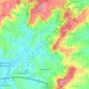
Name: Buissenal topographic map, elevation, terrain.
Location: Buissenal, Frasnes-lez-Anvaing, Ath, Hainaut, Wallonie, Belgique (50.65418 3.63873 50.70431 3.67981)
Average elevation: 243 ft
Minimum elevation: 105 ft
Maximum elevation: 459 ft
Make a donation
Gear up for your next adventure:
As an Amazon Associate, this site earns from qualifying purchases at no extra cost to you.
Other topographic maps
Click on a map to view its topography, its elevation and its terrain.
Make a donation
Gear up for your next adventure:
As an Amazon Associate, this site earns from qualifying purchases at no extra cost to you.
Pommerœul
Connu pour ses vestiges gallo-romains, le village de Pommerœul présente un relief contrasté. L'altitude y varie de 17 mètres au niveau du canal Mons-Condé, qui longe le sud du territoire, jusqu'à 81 mètres dans la forêt de Stambruges, située au nord. Pommerœul se trouve à environ 29 kilomètres de…
Average elevation: 72 ft
Make a donation
Gear up for your next adventure:
As an Amazon Associate, this site earns from qualifying purchases at no extra cost to you.
Make a donation
Gear up for your next adventure:
As an Amazon Associate, this site earns from qualifying purchases at no extra cost to you.
Bois de Silly - Bois de Ligne - Bois d'Enghien (Maquis de Saint-Marcoult)
Belgique > Hainaut > Ath > Marcq > Saint-Marcoult
Average elevation: 276 ft
Make a donation
Gear up for your next adventure:
As an Amazon Associate, this site earns from qualifying purchases at no extra cost to you.
Make a donation
Gear up for your next adventure:
As an Amazon Associate, this site earns from qualifying purchases at no extra cost to you.
Pottelberg
Le Pottelberg, parfois nommé Potelbergh ou mont Potel, est un mont considéré comme le point culminant du pays des Collines au Hainaut. Situé dans la commune de Flobecq, son altitude est de 159 mètres.
Average elevation: 348 ft
Make a donation
Gear up for your next adventure:
As an Amazon Associate, this site earns from qualifying purchases at no extra cost to you.
Make a donation
Gear up for your next adventure:
As an Amazon Associate, this site earns from qualifying purchases at no extra cost to you.