
Thank you for supporting this site ❤️
Make a donation
Make a donation
Gear up for your next adventure:
As an Amazon Associate, this site earns from qualifying purchases at no extra cost to you.
会宁县 topographic map
Click on the map to display elevation.
Thank you for supporting this site ❤️
Make a donation
Make a donation
Gear up for your next adventure:
As an Amazon Associate, this site earns from qualifying purchases at no extra cost to you.
About this map
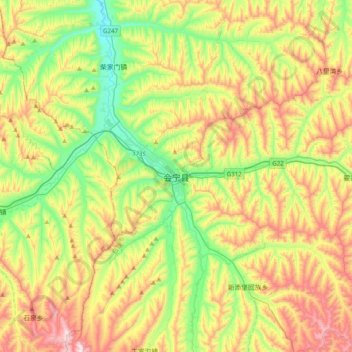
Name: 会宁县 topographic map, elevation, terrain.
Location: 会宁县, 会师镇, 会宁县, 白银市, 甘肃省, 中国 (35.52902 104.89625 35.84902 105.21625)
Average elevation: 6,299 ft
Minimum elevation: 5,377 ft
Maximum elevation: 7,671 ft
Thank you for supporting this site ❤️
Make a donation
Make a donation
Gear up for your next adventure:
As an Amazon Associate, this site earns from qualifying purchases at no extra cost to you.