
Thank you for supporting this site ❤️
Make a donation
Make a donation
Gear up for your next adventure:
As an Amazon Associate, this site earns from qualifying purchases at no extra cost to you.
Ginnaliya topographic map
Click on the map to display elevation.
Thank you for supporting this site ❤️
Make a donation
Make a donation
Gear up for your next adventure:
As an Amazon Associate, this site earns from qualifying purchases at no extra cost to you.
About this map
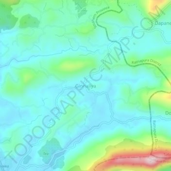
Name: Ginnaliya topographic map, elevation, terrain.
Location: Ginnaliya, Matara District, Southern Province, Sri Lanka (6.30210 80.63473 6.34210 80.67473)
Average elevation: 1,316 ft
Minimum elevation: 1,079 ft
Maximum elevation: 2,231 ft
Thank you for supporting this site ❤️
Make a donation
Make a donation
Gear up for your next adventure:
As an Amazon Associate, this site earns from qualifying purchases at no extra cost to you.