Geolocate

Barichara topographic map

Click on the map to display elevation.

About this map

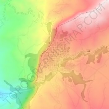
Name: Barichara topographic map, elevation, terrain.

Location: Barichara, Guanentá, Santander, 684041, Colombia (6.61572 -73.24322 6.65572 -73.20322)

Average elevation: 3,924 ft

Minimum elevation: 2,224 ft

Maximum elevation: 5,157 ft

Gear up for your next adventure:

🧣Hiking Neck Gaiter - Multi‑use neck protection for outdoor weather
🧼Biodegradable Camping Soap - Eco‑friendly soap for outdoor hygiene
Backpacking Tent - Lightweight and durable tent for multi‑day hikes
👖Convertible Hiking Pants - Versatile zip-off pants for changing altitudes and temperatures
👟Trail Running Shoes - Lightweight shoes for trail runners

As an Amazon Associate, this site earns from qualifying purchases at no extra cost to you.