Geolocate

Conwy topographic map

Click on the map to display elevation.

About this map

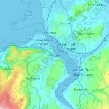
Name: Conwy topographic map, elevation, terrain.

Location: Conwy, Wales, LL32 8DB, United Kingdom (53.24118 -3.86870 53.32118 -3.78870)

Average elevation: 226 ft

Minimum elevation: -3 ft

Maximum elevation: 1,640 ft

Gear up for your next adventure:

🎒Trekking Poles - Sturdy poles for balance and stability on rough terrain
🥾Hiking Shoes - Durable and comfortable shoes for trail hiking
🔭Compact Binoculars - HD vision for scouting terrain and identifying distant landmarks
🌧️Backpack Rain Cover - Keep gear dry in wet weather
🥩Freeze-Dried Meals - Nutritious and lightweight food for remote expeditions

As an Amazon Associate, this site earns from qualifying purchases at no extra cost to you.