
Canton Lake topographic map
Interactive map
Click on the map to display elevation.
About this map
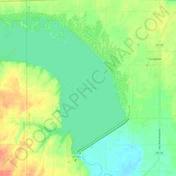
Name: Canton Lake topographic map, elevation, terrain.
Location: Canton Lake, Blaine County, Oklahoma, United States (36.07861 -98.68802 36.15648 -98.57009)
Average elevation: 1,647 ft
Minimum elevation: 1,575 ft
Maximum elevation: 1,772 ft
Other topographic maps
Click on a map to view its topography, its elevation and its terrain.
Greenfield
United States > Oklahoma > Blaine County
Greenfield, Blaine County, Oklahoma, United States
Average elevation: 1,483 ft
Geary
United States > Oklahoma > Blaine County
Geary, Blaine County, Oklahoma, 73040, United States
Average elevation: 1,506 ft
Okeene
United States > Oklahoma > Blaine County
Okeene, Blaine County, Oklahoma, 73763, United States
Average elevation: 1,211 ft
Watonga
United States > Oklahoma > Blaine County
Watonga, Blaine County, Oklahoma, 73772, United States
Average elevation: 1,532 ft