Geolocate

Andover topographic map

Click on the map to display elevation.

About this map

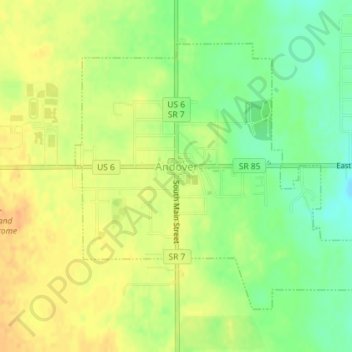
Name: Andover topographic map, elevation, terrain.

Location: Andover, Ashtabula County, Ohio, 44003, United States (41.59620 -80.58174 41.61659 -80.55181)

Average elevation: 1,089 ft

Minimum elevation: 1,027 ft

Maximum elevation: 1,135 ft

Ashtabula County trails, hiking, mountain biking, running and outdoor activities

Other topographic maps

Click on a map to view its topography, its elevation and its terrain.

Chapel

United States > Ohio > Ashtabula County

Average elevation: 846 ft

Phelps Creek

United States > Ohio > Ashtabula County

Average elevation: 1,070 ft

Pierpont

United States > Ohio > Ashtabula County

Average elevation: 1,001 ft

Kingsville

United States > Ohio > Ashtabula County

Average elevation: 741 ft

Gear up for your next adventure:

🧯Portable Fire Pit - Compact fire pit for camping spots
🪶Camp Gear Gift Set - Perfect gift bundle for outdoor fans
📶Satellite Messenger - Communication device off‑grid
🪶Survival Guide Book - Expert advice for emergency preparedness
🖼️Topo Map Wall Art - Decorative topographic prints of famous peaks and regions

As an Amazon Associate, this site earns from qualifying purchases at no extra cost to you.