
Make a donation
Gear up for your next adventure:
As an Amazon Associate, this site earns from qualifying purchases at no extra cost to you.
Wethau topographic map
Click on the map to display elevation.
Make a donation
Gear up for your next adventure:
As an Amazon Associate, this site earns from qualifying purchases at no extra cost to you.
Wethau
Bemerkenswert ist die den Ort auf einer Anhöhe deutlich überragende Dorfkirche Wethau vom Anfang des 19. Jahrhunderts. Als Kulturdenkmal Beachtung findet auch das Hoftor am Gebäude Friedensstraße 20. Das 1667 errichtete, 1791 renovierte Tor ist mit Inschriften und figürlichen Reliefs geschmückt.
Make a donation
Gear up for your next adventure:
As an Amazon Associate, this site earns from qualifying purchases at no extra cost to you.
About this map
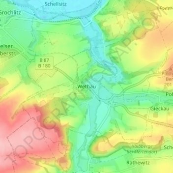
Name: Wethau topographic map, elevation, terrain.
Average elevation: 505 ft
Minimum elevation: 322 ft
Maximum elevation: 755 ft
Make a donation
Gear up for your next adventure:
As an Amazon Associate, this site earns from qualifying purchases at no extra cost to you.