
Make a donation
Gear up for your next adventure:
As an Amazon Associate, this site earns from qualifying purchases at no extra cost to you.
Rockland Township topographic map
Click on the map to display elevation.
Make a donation
Gear up for your next adventure:
As an Amazon Associate, this site earns from qualifying purchases at no extra cost to you.
About this map
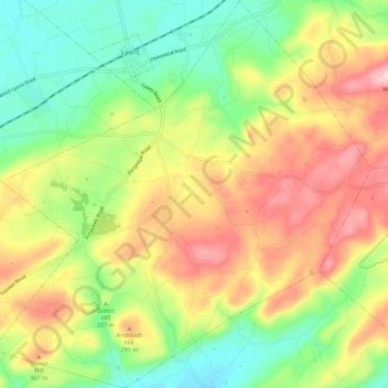
Name: Rockland Township topographic map, elevation, terrain.
Location: Rockland Township, Berks County, Pennsylvania, United States (40.40966 -75.79683 40.49305 -75.68958)
Average elevation: 741 ft
Minimum elevation: 361 ft
Maximum elevation: 1,220 ft
Berks County trails, hiking, mountain biking, running and outdoor activities
Make a donation
Gear up for your next adventure:
As an Amazon Associate, this site earns from qualifying purchases at no extra cost to you.
Other topographic maps
Click on a map to view its topography, its elevation and its terrain.
Boyers Junction
United States > Pennsylvania > Berks County > Rockland Township
Average elevation: 794 ft
New Jerusalem
United States > Pennsylvania > Berks County > Rockland Township
Average elevation: 827 ft
Make a donation
Gear up for your next adventure:
As an Amazon Associate, this site earns from qualifying purchases at no extra cost to you.