
Thank you for supporting this site ❤️
Make a donation
Make a donation
Gear up for your next adventure:
As an Amazon Associate, this site earns from qualifying purchases at no extra cost to you.
Orcomone topographic map
Click on the map to display elevation.
Thank you for supporting this site ❤️
Make a donation
Make a donation
Gear up for your next adventure:
As an Amazon Associate, this site earns from qualifying purchases at no extra cost to you.
About this map
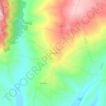
Name: Orcomone topographic map, elevation, terrain.
Location: Orcomone, Morra De Sanctis, Avellino, Campania, Italia (40.90054 15.25110 40.94054 15.29110)
Average elevation: 2,090 ft
Minimum elevation: 1,535 ft
Maximum elevation: 2,881 ft
Thank you for supporting this site ❤️
Make a donation
Make a donation
Gear up for your next adventure:
As an Amazon Associate, this site earns from qualifying purchases at no extra cost to you.