
Ulan-Ude topographic map
Interactive map
Click on the map to display elevation.
About this map
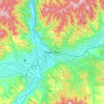
Name: Ulan-Ude topographic map, elevation, terrain.
Average elevation: 2,277 ft
Minimum elevation: 1,598 ft
Maximum elevation: 4,190 ft
Other topographic maps
Click on a map to view its topography, its elevation and its terrain.
Ulan-Ude
Russia > Buryatia > городской округ Улан-Удэ
Ulan-Ude, городской округ Улан-Удэ, Buryatia, Far Eastern Federal District, Russia
Average elevation: 2,362 ft