
Bashful Peak topographic map
Interactive map
Click on the map to display elevation.
About this map
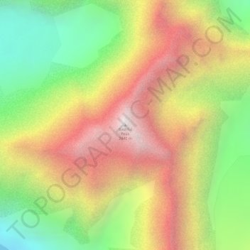
Name: Bashful Peak topographic map, elevation, terrain.
Location: Bashful Peak, Anchorage, Alaska, USA (61.30721 -148.87012 61.30731 -148.87002)
Average elevation: 5,394 ft
Minimum elevation: 2,887 ft
Maximum elevation: 7,989 ft
Other topographic maps
Click on a map to view its topography, its elevation and its terrain.
Minnesota Park
Minnesota Park, Anchorage, Alaska, USA
Average elevation: 95 ft
Mount Alyeska
Mount Alyeska, Anchorage, Alaska, USA
Average elevation: 2,336 ft
Explorer Glacier
Explorer Glacier, Trail of Blue Ice, Anchorage, Alaska, USA
Average elevation: 1,834 ft