
Paita topographic map
Click on the map to display elevation.
Paita
Al sur de la ciudad se encuentra un conjunto de elevaciones que destacan no solo por su altitudes poco usuales en el norte del Perú, sino también por su interés legendario-histórico, geológico y mineralógico. Este conjunto de elevaciones se le conoce como La Silla de Paita o Cerro Azul (debido a la tonalidad azul que presenta de lejos).
About this map
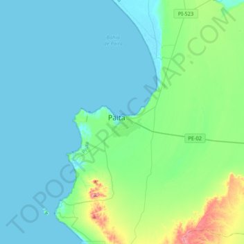
Name: Paita topographic map, elevation, terrain.
Location: Paita, Provincia de Paita, Piura, 20701, Perú (-5.24516 -81.27368 -4.92516 -80.95368)
Average elevation: 167 ft
Minimum elevation: -7 ft
Maximum elevation: 1,178 ft
Other topographic maps
Click on a map to view its topography, its elevation and its terrain.