
Martelange topographic map
Interactive map
Click on the map to display elevation.
About this map
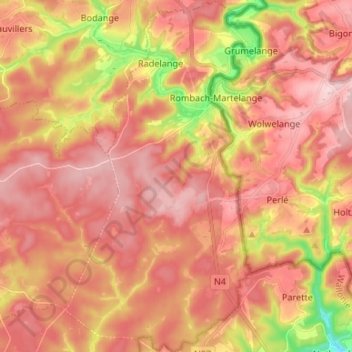
Name: Martelange topographic map, elevation, terrain.
Location: Martelange, Arlon, Luxembourg, Wallonie, Belgique (49.77206 5.68456 49.85778 5.75854)
Average elevation: 1,467 ft
Minimum elevation: 1,024 ft
Maximum elevation: 1,703 ft
Other topographic maps
Click on a map to view its topography, its elevation and its terrain.
Forêt d'Anlier
Belgique > Luxembourg > Arlon > Martelange
Forêt d'Anlier, Martelange, Arlon, Luxembourg, Wallonie, 6630, Belgique
Average elevation: 1,421 ft
Sampont
Belgique > Luxembourg > Arlon > Arlon
Sampont, Arlon, Luxembourg, Wallonie, 6700, Belgique
Average elevation: 1,175 ft
Grendel
Belgique > Luxembourg > Arlon
Grendel, Attert, Arlon, Luxembourg, Wallonie, 6717, Belgique
Average elevation: 1,050 ft
Hondelange
Belgique > Luxembourg > Arlon > Messancy
Hondelange, Messancy, Arlon, Luxembourg, Wallonie, Belgique
Average elevation: 1,096 ft
Schockville
Belgique > Luxembourg > Arlon
Schockville, Attert, Arlon, Luxembourg, Wallonie, 6717, Belgique
Average elevation: 1,188 ft
Turpange
Belgique > Luxembourg > Arlon
Turpange, Messancy, Arlon, Luxembourg, Wallonie, 6780, Belgique
Average elevation: 1,053 ft
Tontelange
Belgique > Luxembourg > Arlon > Attert
Tontelange, Attert, Arlon, Luxembourg, Wallonie, 6717, Belgique
Average elevation: 1,148 ft
Fouches
Belgique > Luxembourg > Arlon > Arlon
Fouches, Arlon, Luxembourg, Wallonie, 6741, Belgique
Average elevation: 1,188 ft
Radelange
Belgique > Luxembourg > Arlon
Radelange, Martelange, Arlon, Luxembourg, Wallonie, 6630, Belgique
Average elevation: 1,391 ft
Heinsch
Belgique > Luxembourg > Arlon > Arlon
Heinsch, Arlon, Luxembourg, Wallonie, Belgique
Average elevation: 1,230 ft
Bonnert
Belgique > Luxembourg > Arlon > Arlon
Bonnert, Arlon, Luxembourg, Wallonie, Belgique
Average elevation: 1,224 ft
Nobressart
Belgique > Luxembourg > Arlon
Nobressart, Attert, Arlon, Luxembourg, Wallonie, 6717, Belgique
Average elevation: 1,299 ft
Athus
Belgique > Luxembourg > Arlon > Aubange
Athus, Aubange, Arlon, Luxembourg, Wallonie, 6791, Belgique
Average elevation: 997 ft
Toernich
Belgique > Luxembourg > Arlon > Arlon
Toernich, Arlon, Luxembourg, Wallonie, Belgique
Average elevation: 1,171 ft
Wolkrange
Belgique > Luxembourg > Arlon > Wolkrange
Wolkrange, Messancy, Arlon, Luxembourg, Wallonie, Belgique
Average elevation: 1,096 ft
Halanzy
Belgique > Luxembourg > Arlon
Halanzy, Aubange, Arlon, Luxembourg, Wallonie, 6792, Belgique
Average elevation: 1,010 ft
Aubange
Belgique > Luxembourg > Arlon
Aubange, Arlon, Luxembourg, Wallonie, Belgique
Average elevation: 1,063 ft
Lischert
Belgique > Luxembourg > Arlon
Lischert, Attert, Arlon, Luxembourg, Wallonie, 6717, Belgique
Average elevation: 1,175 ft
Messancy
Belgique > Luxembourg > Arlon
Messancy, Arlon, Luxembourg, Wallonie, Belgique
Average elevation: 1,096 ft
Parette
Belgique > Luxembourg > Arlon
Parette, Attert, Arlon, Luxembourg, Wallonie, 6717, Belgique
Average elevation: 1,362 ft
Martelange
Belgique > Luxembourg > Arlon > Martelange
Martelange, Arlon, Luxembourg, Wallonie, Belgique
Average elevation: 1,467 ft
Bébange
Belgique > Luxembourg > Arlon
Bébange, Messancy, Arlon, Luxembourg, Wallonie, 6782, Belgique
Average elevation: 1,073 ft
Attert
Belgique > Luxembourg > Arlon
Attert, Arlon, Luxembourg, Wallonie, 6717, Belgique
Average elevation: 1,191 ft
Lottert
Belgique > Luxembourg > Arlon > Lottert
Lottert, Attert, Arlon, Luxembourg, Wallonie, 6717, Belgique
Average elevation: 1,198 ft