
Schweinbach topographic map
Interactive map
Click on the map to display elevation.
About this map
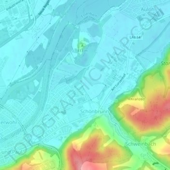
Name: Schweinbach topographic map, elevation, terrain.
Location: Schweinbach, Landshut, Bayern, 84028, Deutschland (48.55182 12.18971 48.55752 12.19401)
Average elevation: 1,325 ft
Minimum elevation: 1,247 ft
Maximum elevation: 1,621 ft
Other topographic maps
Click on a map to view its topography, its elevation and its terrain.
Schaumburg
Deutschland > Bayern > Landshut
Schaumburg, Frauenberg, Landshut, Bayern, 84036, Deutschland
Average elevation: 1,375 ft
Burg Trausnitz
Deutschland > Bayern > Landshut
Burg Trausnitz, 168, Burg Trausnitz, Berg, Landshut, Bayern, 84036, Deutschland
Average elevation: 1,398 ft
Kranzed
Deutschland > Bayern > Landshut
Kranzed, Schönbrunn, Landshut, Bayern, 84036, Deutschland
Average elevation: 1,407 ft