
Make a donation
Gear up for your next adventure:
As an Amazon Associate, this site earns from qualifying purchases at no extra cost to you.
Calahorra topographic map
Click on the map to display elevation.
Make a donation
Gear up for your next adventure:
As an Amazon Associate, this site earns from qualifying purchases at no extra cost to you.
Calahorra
The city is located on a hill at an altitude of 358 metres at the confluence of the Ebro and Cidacos rivers, and has an area of 91.41 km². Calahorra is the second-largest city in La Rioja in population and importance, after the capital, Logroño. Its population is 23,923 people.
Make a donation
Gear up for your next adventure:
As an Amazon Associate, this site earns from qualifying purchases at no extra cost to you.
About this map
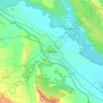
Name: Calahorra topographic map, elevation, terrain.
Location: Calahorra, Rioja, 26500, Spain (42.23731 -2.02894 42.36931 -1.86621)
Average elevation: 1,155 ft
Minimum elevation: 932 ft
Maximum elevation: 2,044 ft
Make a donation
Gear up for your next adventure:
As an Amazon Associate, this site earns from qualifying purchases at no extra cost to you.
Other topographic maps
Click on a map to view its topography, its elevation and its terrain.
Make a donation
Gear up for your next adventure:
As an Amazon Associate, this site earns from qualifying purchases at no extra cost to you.
Make a donation
Gear up for your next adventure:
As an Amazon Associate, this site earns from qualifying purchases at no extra cost to you.