Geolocate

Gonder topographic map

Click on the map to display elevation.

About this map

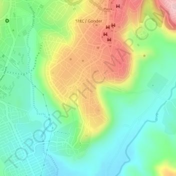
Name: Gonder topographic map, elevation, terrain.

Location: Gonder, North Gondar, Amhara Region, 6200, Ethiopia (12.59000 37.45667 12.61000 37.47667)

Average elevation: 6,975 ft

Minimum elevation: 6,670 ft

Maximum elevation: 7,434 ft

Gear up for your next adventure:

🧤Hiking Gloves - Protective gloves for rugged trails
Backpacking Tents - Weight-optimized shelters for multi-day topographic surveys
🩹Survival Bandages - High‑quality bandages for emergencies
🪑Portable Camp Table - Compact table for campsite meals
📱Heavy-Duty Phone Cases - Drop-proof and waterproof protection for outdoor navigation

As an Amazon Associate, this site earns from qualifying purchases at no extra cost to you.