Geolocate

Lockport topographic map

Click on the map to display elevation.

About this map
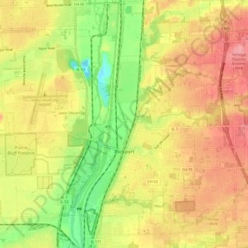
Name: Lockport topographic map, elevation, terrain.

Location: Lockport, Will County, Illinois, United States (41.55610 -88.07589 41.64158 -87.96348)

Average elevation: 650 ft

Minimum elevation: 469 ft

Maximum elevation: 794 ft

Will County trails, hiking, mountain biking, running and outdoor activities

Other topographic maps

Click on a map to view its topography, its elevation and its terrain.

Marley

United States > Illinois > Will County

Average elevation: 702 ft

Drummond

United States > Illinois > Will County

Average elevation: 548 ft

Welco Corners

United States > Illinois > Will County > Bolingbrook

Average elevation: 719 ft

Puddle Pond

United States > Illinois > Will County > Plainfield

Average elevation: 614 ft

Arbury Hills

United States > Illinois > Will County

Average elevation: 709 ft

Gear up for your next adventure:

🚗GPS Dash Cams - Record your scenic drives through mountain passes and canyons
🎒Outdoor Daypacks - Lightweight backpacks designed for carrying maps and essential gear
🧭Orienteering Set - Complete compass and map reading kit
🦺Reflective Outdoor Gear - Safety gear for low‑light conditions
🪶Wildlife Field Guides - Learn animal tracking and species ID

As an Amazon Associate, this site earns from qualifying purchases at no extra cost to you.