Geolocate

Dorothea Dix Park topographic map

Click on the map to display elevation.

Gear up for your next adventure:

As an Amazon Associate, this site earns from qualifying purchases at no extra cost to you.

About this map

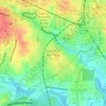
Name: Dorothea Dix Park topographic map, elevation, terrain.

Location: Dorothea Dix Park, Warehouse District, Raleigh, Wake County, North Carolina, United States (35.76230 -78.66648 35.77773 -78.64841)

Average elevation: 318 ft

Minimum elevation: 230 ft

Maximum elevation: 430 ft

Wake County trails, hiking, mountain biking, running and outdoor activities

👉 Easily get elevation data in JSON, GeoTIFF and KML formats using Elevation API
Thank you for supporting this site ❤️
Make a donation

Gear up for your next adventure:

As an Amazon Associate, this site earns from qualifying purchases at no extra cost to you.

Other topographic maps

Click on a map to view its topography, its elevation and its terrain.

Tysonville

United States > North Carolina > Wake County > Raleigh

Average elevation: 387 ft

Isle Forest

United States > North Carolina > Wake County > Raleigh

Average elevation: 371 ft

Markwood

United States > North Carolina > Wake County > Raleigh > Markwood

Average elevation: 322 ft

Gear up for your next adventure:

🔦LED Headlamp - Bright and durable LED headlamp for night navigation
💧Water Purification System - Clean water on the trail with reliable purifiers
🧺Microfiber Travel Towels - Compact and fast-drying towels for trail use

As an Amazon Associate, this site earns from qualifying purchases at no extra cost to you.