
Make a donation
Gear up for your next adventure:
As an Amazon Associate, this site earns from qualifying purchases at no extra cost to you.
Kayalana Lake topographic map
Click on the map to display elevation.
Make a donation
Gear up for your next adventure:
As an Amazon Associate, this site earns from qualifying purchases at no extra cost to you.
About this map
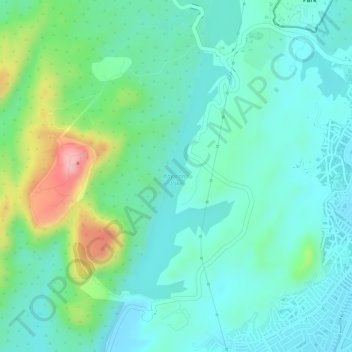
Name: Kayalana Lake topographic map, elevation, terrain.
Average elevation: 945 ft
Minimum elevation: 810 ft
Maximum elevation: 1,306 ft
Make a donation
Gear up for your next adventure:
As an Amazon Associate, this site earns from qualifying purchases at no extra cost to you.
Other topographic maps
Click on a map to view its topography, its elevation and its terrain.
(Shree Pravshnath park )Prabhu Pravshnath nagar pal balaji
India > Rajasthan > Jodhpur Tehsil > Jodhpur
Average elevation: 758 ft
Make a donation
Gear up for your next adventure:
As an Amazon Associate, this site earns from qualifying purchases at no extra cost to you.
(Shree Pravshnath park )Prabhu Pravshnath nagar pal balaji
India > Rajasthan > Jodhpur Tehsil > Jodhpur
Average elevation: 758 ft
Make a donation
Gear up for your next adventure:
As an Amazon Associate, this site earns from qualifying purchases at no extra cost to you.