Nakuri topographic map
Interactive map
Click on the map to display elevation.
About this map
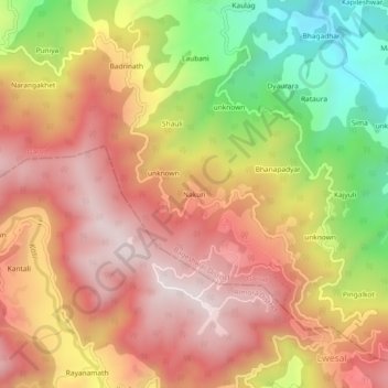
Name: Nakuri topographic map, elevation, terrain.
Location: Nakuri, Garud, Bageshwar, Uttarakhand, 263639, India (29.83840 79.56790 29.87840 79.60790)
Average elevation: 5,351 ft
Minimum elevation: 3,940 ft
Maximum elevation: 6,348 ft
Other topographic maps
Click on a map to view its topography, its elevation and its terrain.
Garur
India > Uttarakhand > Garud
Garur, Garud, Bageshwar District, Uttarakhand, 263641, India
Average elevation: 4,035 ft
Lakhani
India > Uttarakhand > Garud
Lakhani, Garud, Bageshwar District, Uttarakhand, 263641, India
Average elevation: 4,718 ft