
Make a donation
Gear up for your next adventure:
As an Amazon Associate, this site earns from qualifying purchases at no extra cost to you.
Paimparé topographic map
Click on the map to display elevation.
Make a donation
Gear up for your next adventure:
As an Amazon Associate, this site earns from qualifying purchases at no extra cost to you.
About this map
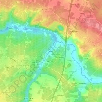
Name: Paimparé topographic map, elevation, terrain.
Average elevation: 200 ft
Minimum elevation: 56 ft
Maximum elevation: 348 ft
Make a donation
Gear up for your next adventure:
As an Amazon Associate, this site earns from qualifying purchases at no extra cost to you.
Other topographic maps
Click on a map to view its topography, its elevation and its terrain.
Saint-Aubin-de-Luigné
France > Pays de la Loire > Maine-et-Loire > Val-du-Layon
La commune s'étend sur plus de 15 km2 (1 519 hectares), et son altitude varie de 12 à 104 mètres.
Average elevation: 200 ft
Saint-Lambert-du-Lattay
France > Pays de la Loire > Maine-et-Loire > Val-du-Layon
Sa superficie est de 14,44 km2 et son altitude varie de 16 à 96 mètres (moyenne de 66 m).
Average elevation: 213 ft