
Make a donation
Gear up for your next adventure:
As an Amazon Associate, this site earns from qualifying purchases at no extra cost to you.
Possession Island topographic map
Click on the map to display elevation.
Make a donation
Gear up for your next adventure:
As an Amazon Associate, this site earns from qualifying purchases at no extra cost to you.
Possession Island
The island has been identified as an Important Bird Area (IBA) by BirdLife International as a breeding site for seabirds, of which there are at least 26 breeding species. Birds nesting in relatively large numbers include king, northern rockhopper and macaroni penguins, wandering, sooty and light-mantled albatrosses, northern giant petrels, medium-billed prions, Kerguelen and soft-plumaged petrels, and South Georgia diving petrels. Other island breeders in smaller numbers are southern giant petrels, grey-headed albatrosses and Kerguelen terns. Crozet blue-eyed shags, black-faced sheathbills and Eaton's pintails are resident. The smaller birds nest only at higher altitudes because of their vulnerability to rat predation at lower levels.
Make a donation
Gear up for your next adventure:
As an Amazon Associate, this site earns from qualifying purchases at no extra cost to you.
About this map
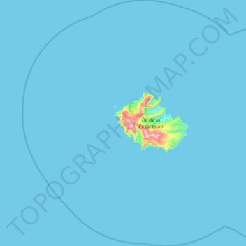
Name: Possession Island topographic map, elevation, terrain.
Average elevation: 43 ft
Minimum elevation: 0 ft
Maximum elevation: 2,943 ft
Make a donation
Gear up for your next adventure:
As an Amazon Associate, this site earns from qualifying purchases at no extra cost to you.
Other topographic maps
Click on a map to view its topography, its elevation and its terrain.
Make a donation
Gear up for your next adventure:
As an Amazon Associate, this site earns from qualifying purchases at no extra cost to you.