Geolocate

Leut topographic map

Click on the map to display elevation.

About this map

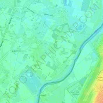
Name: Leut topographic map, elevation, terrain.

Location: Leut, Maasmechelen, Tongeren, Limburg, Vlaanderen, België (50.97704 5.71067 51.00138 5.75937)

Average elevation: 118 ft

Minimum elevation: 92 ft

Maximum elevation: 161 ft

Other topographic maps

Click on a map to view its topography, its elevation and its terrain.

Proosterbos

België > Limburg > Tongeren > Maasmechelen

Average elevation: 154 ft

Mechelse Heide

België > Limburg > Tongeren > Maasmechelen

Average elevation: 210 ft

Rode Terril

België > Limburg > Tongeren > Maasmechelen

Average elevation: 187 ft

Daalgrimbie

België > Limburg > Tongeren > Maasmechelen > Opgrimbie > Daalgrimbie

Average elevation: 144 ft

Gear up for your next adventure:

🧭GPS Watch Accessories - Bands and chargers for GPS watches
🌐World Map Poster - Decorative world maps with topographic info
🧷Carabiner Set - Durable clips for gear attachment
🧣Merino Neck Gaiters - Multi-functional headwear for wind and sun protection
🎒Hydration Pack - Hands‑free water reservoir for long hikes

As an Amazon Associate, this site earns from qualifying purchases at no extra cost to you.