Geolocate

Bella topographic map

Click on the map to display elevation.

About this map

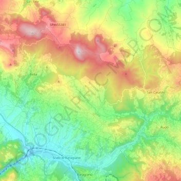
Name: Bella topographic map, elevation, terrain.

Location: Bella, Potenza, Basilicata, 85051, Italy (40.69572 15.51880 40.79757 15.71482)

Average elevation: 2,418 ft

Minimum elevation: 1,014 ft

Maximum elevation: 4,554 ft

Other topographic maps

Click on a map to view its topography, its elevation and its terrain.

Agri

Italy > Basilicata > Potenza > San Martino d'Agri

Average elevation: 1,611 ft

Gear up for your next adventure:

🌧️Backpack Rain Cover - Keep gear dry in wet weather
🪓Survival Multi‑Tool - Versatile tool for camp and trail tasks
🌎3D Topographic Globes - Raised relief globes for a tactile understanding of geography
📶Vehicle Signal Boosters - Improve reception in rural areas while driving to trailheads
🧥Waterproof Jacket for Hiking - Breathable and rugged rain jacket for outdoor excursions

As an Amazon Associate, this site earns from qualifying purchases at no extra cost to you.