Geolocate

Glidden topographic map

Click on the map to display elevation.

About this map

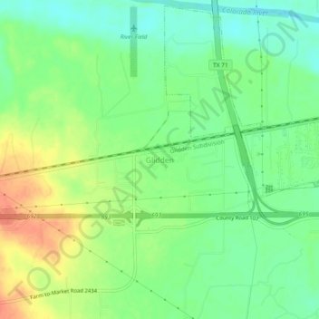
Name: Glidden topographic map, elevation, terrain.

Location: Glidden, Colorado County, Texas, 78943, United States (29.68051 -96.60786 29.72051 -96.56786)

Average elevation: 243 ft

Minimum elevation: 177 ft

Maximum elevation: 331 ft

Colorado County trails, hiking, mountain biking, running and outdoor activities

Other topographic maps

Click on a map to view its topography, its elevation and its terrain.

Columbus

United States > Texas > Colorado County

Average elevation: 200 ft

Weimar

United States > Texas > Colorado County

Average elevation: 390 ft

Eagle Lake

United States > Texas > Colorado County

Average elevation: 177 ft

Eagle Lake

United States > Texas > Colorado County

Average elevation: 177 ft

Weimar

United States > Texas > Colorado County

Average elevation: 390 ft

Eagle Lake

United States > Texas > Colorado County

Average elevation: 177 ft

Eagle Lake

United States > Texas > Colorado County

Average elevation: 177 ft

Gear up for your next adventure:

🚁Photography Drones - Capture stunning aerial views of landforms and topography
🥾Hiking Shoes - Durable and comfortable shoes for trail hiking
🎒Outdoor Daypacks - Lightweight backpacks designed for carrying maps and essential gear
☀️Outdoor Sunscreen - High protection sunscreen for outdoor activities
🪶Fire Starter Kit - Reliable fire starter for survival and camping

As an Amazon Associate, this site earns from qualifying purchases at no extra cost to you.