
Portsalon topographic map
Click on the map to display elevation.
About this map
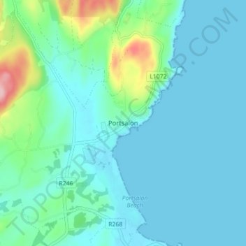
Name: Portsalon topographic map, elevation, terrain.
Location: Portsalon, Letterkenny, County Donegal, Ulster, Ireland (55.18889 -7.64234 55.22889 -7.60234)
Average elevation: 89 ft
Minimum elevation: 0 ft
Maximum elevation: 545 ft
Other topographic maps
Click on a map to view its topography, its elevation and its terrain.