Geolocate

Challamoco topographic map

Click on the map to display elevation.

About this map

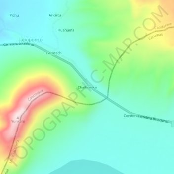
Name: Challamoco topographic map, elevation, terrain.

Location: Challamoco, Candarave, Province of Candarave, Tacna, Peru (-16.87366 -70.24793 -16.83366 -70.20793)

Average elevation: 15,305 ft

Minimum elevation: 14,908 ft

Maximum elevation: 16,247 ft

Gear up for your next adventure:

🕶️Glacier Sunglasses - Side shields to protect eyes from high-altitude snow glare
🥾Hiking Shoes - Durable and comfortable shoes for trail hiking
🪶Camping Sleeping Pad - Comfortable sleeping pad for backpacking
🧢Outdoor Hiking Hat - Sun protection hat for outdoor explorers
💧Water Filtration Bottles - Safely drink from streams and lakes while exploring

As an Amazon Associate, this site earns from qualifying purchases at no extra cost to you.