
Thank you for supporting this site ❤️
Make a donation
Make a donation
Gear up for your next adventure:
As an Amazon Associate, this site earns from qualifying purchases at no extra cost to you.
Solsona topographic map
Click on the map to display elevation.
Thank you for supporting this site ❤️
Make a donation
Make a donation
Gear up for your next adventure:
As an Amazon Associate, this site earns from qualifying purchases at no extra cost to you.
About this map
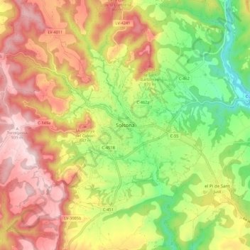
Name: Solsona topographic map, elevation, terrain.
Location: Solsona, Solsonais, Lérida, Catalogne, 25280, Espagne (41.95458 1.47840 42.03458 1.55840)
Average elevation: 2,411 ft
Minimum elevation: 1,745 ft
Maximum elevation: 3,068 ft
Thank you for supporting this site ❤️
Make a donation
Make a donation
Gear up for your next adventure:
As an Amazon Associate, this site earns from qualifying purchases at no extra cost to you.