
Make a donation
Gear up for your next adventure:
As an Amazon Associate, this site earns from qualifying purchases at no extra cost to you.
Tongeren topographic map
Click on the map to display elevation.
Make a donation
Gear up for your next adventure:
As an Amazon Associate, this site earns from qualifying purchases at no extra cost to you.
Tongeren
Het centrum van Tongeren ligt op de zuidelijke helling van een heuvel nabij de Jeker. De hoogte binnen de stadswallen stijgt van 87 m aan de oevers van de Jeker tot 105 m aan de uitvalswegen naar Hasselt en Bilzen. Ten noordwesten van het centrum zijn de hellingen van deze heuvel steiler en daalt de hoogte tot 75 m in de wijk Broek.
Make a donation
Gear up for your next adventure:
As an Amazon Associate, this site earns from qualifying purchases at no extra cost to you.
About this map
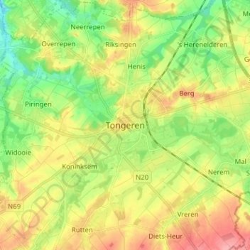
Name: Tongeren topographic map, elevation, terrain.
Location: Tongeren, Limburg, Vlaanderen, 3700, België (50.74063 5.42392 50.82063 5.50392)
Average elevation: 312 ft
Minimum elevation: 177 ft
Maximum elevation: 472 ft
Make a donation
Gear up for your next adventure:
As an Amazon Associate, this site earns from qualifying purchases at no extra cost to you.