Geolocate

Seigendorf topographic map

Click on the map to display elevation.

Seigendorf

Es liegt östlich von Hirschaid. Über die Kreisstraße BA 27 erreicht man nach einem Kilometer die Einfahrt Hirschaid der A 73. Durch den östlichen Ortsbereich verläuft die Staatsstraße 2210. Seigendorf liegt auf einer durchschnittlichen Höhe von 273 Metern über dem Meeresspiegel.

Wikipedia (CC-BY-SA 3.0)

About this map

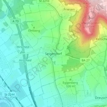
Name: Seigendorf topographic map, elevation, terrain.

Location: Seigendorf, Hirschaid, Landkreis Bamberg, Bayern, 96114, Deutschland (49.80420 11.00630 49.84420 11.04630)

Average elevation: 1,047 ft

Minimum elevation: 781 ft

Maximum elevation: 1,791 ft

Gear up for your next adventure:

🎒Trekking Poles - Sturdy poles for balance and stability on rough terrain
🧯Portable Fire Pit - Compact fire pit for camping spots
🌧️Backpack Rain Cover - Keep gear dry in wet weather
🪶Wildlife Field Guides - Learn animal tracking and species ID
🧭Compass with Lanyard - Easy‑carry compass for navigation

As an Amazon Associate, this site earns from qualifying purchases at no extra cost to you.