
Thank you for supporting this site ❤️
Make a donation
Make a donation
Gear up for your next adventure:
As an Amazon Associate, this site earns from qualifying purchases at no extra cost to you.
Guayllabamba topographic map
Click on the map to display elevation.
Thank you for supporting this site ❤️
Make a donation
Make a donation
Gear up for your next adventure:
As an Amazon Associate, this site earns from qualifying purchases at no extra cost to you.
About this map
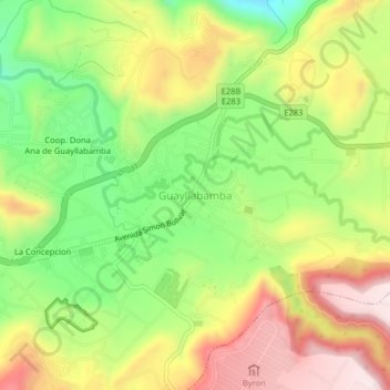
Name: Guayllabamba topographic map, elevation, terrain.
Location: Guayllabamba, Quito, Pichincha, 170203, Ecuador (-0.07877 -78.36550 -0.03877 -78.32550)
Average elevation: 7,221 ft
Minimum elevation: 6,496 ft
Maximum elevation: 8,015 ft
Thank you for supporting this site ❤️
Make a donation
Make a donation
Gear up for your next adventure:
As an Amazon Associate, this site earns from qualifying purchases at no extra cost to you.