
Make a donation
Gear up for your next adventure:
As an Amazon Associate, this site earns from qualifying purchases at no extra cost to you.
Inukjuak (Village) topographic map
Click on the map to display elevation.
Make a donation
Gear up for your next adventure:
As an Amazon Associate, this site earns from qualifying purchases at no extra cost to you.
About this map
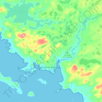
Name: Inukjuak (Village) topographic map, elevation, terrain.
Location: Inukjuak (Village), Kativik, Nord-du-Québec, Quebec, Canada (58.42695 -78.25490 58.51346 -78.04690)
Average elevation: 95 ft
Minimum elevation: -3 ft
Maximum elevation: 486 ft
Make a donation
Gear up for your next adventure:
As an Amazon Associate, this site earns from qualifying purchases at no extra cost to you.
Other topographic maps
Click on a map to view its topography, its elevation and its terrain.
Labrador Peninsula
Canada > Quebec > Kativik > Rivière-Koksoak > Caniapiscau
Average elevation: 1,903 ft
Richmond Gulf
Canada > Quebec > Kativik > Baie-d'Hudson
The topography of Lake Tasuijaq is the consequence of two geological faults running parallel to the coast. The resulting dislocation has given rise to the cliffs that dominate the western shore of the lake.
Average elevation: 0 ft
Labrador Peninsula
Canada > Quebec > Kativik > Rivière-Koksoak > Caniapiscau
Average elevation: 1,903 ft
Labrador Peninsula
Canada > Quebec > Kativik > Rivière-Koksoak > Caniapiscau
Average elevation: 1,903 ft
Make a donation
Gear up for your next adventure:
As an Amazon Associate, this site earns from qualifying purchases at no extra cost to you.
Labrador Peninsula
Canada > Quebec > Kativik > Rivière-Koksoak > Caniapiscau
Average elevation: 1,903 ft