
Make a donation
Gear up for your next adventure:
As an Amazon Associate, this site earns from qualifying purchases at no extra cost to you.
Altenberg topographic map
Click on the map to display elevation.
Make a donation
Gear up for your next adventure:
As an Amazon Associate, this site earns from qualifying purchases at no extra cost to you.
Altenberg
Der Ort ist auf der Topographischen Aufnahme der Rheinlande von 1824 und auf der Preußischen Uraufnahme von 1840 als Altenberg verzeichnet. Ab der Preußischen Neuaufnahme von 1892 ist er auf Messtischblättern regelmäßig als Altenberg verzeichnet. Altenberg gehörte zur katholischen Pfarrei Odenthal, bis es 1915 als eigene Katholische Pfarrgemeinde St. Mariä Himmelfahrt abgepfarrt wurde mit dem Dom Unserer Lieben Frau zu Altenberg als Pfarrkirche. 1950 wurde Altenberg eigenständige evangelische Pfarrgemeinde.
Make a donation
Gear up for your next adventure:
As an Amazon Associate, this site earns from qualifying purchases at no extra cost to you.
About this map
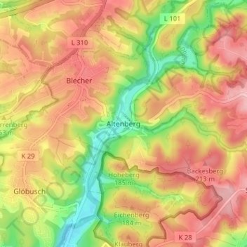
Name: Altenberg topographic map, elevation, terrain.
Average elevation: 545 ft
Minimum elevation: 259 ft
Maximum elevation: 761 ft
Make a donation
Gear up for your next adventure:
As an Amazon Associate, this site earns from qualifying purchases at no extra cost to you.
Other topographic maps
Click on a map to view its topography, its elevation and its terrain.
Scherfbachtal
Deutschland > Nordrhein-Westfalen > Rheinisch-Bergischer Kreis > Odenthal > Höffe
Average elevation: 541 ft
Unterbreidbach
Deutschland > Nordrhein-Westfalen > Rheinisch-Bergischer Kreis > Odenthal > Neschen > Unterbreidbach
Average elevation: 650 ft