
Thank you for supporting this site ❤️
Make a donation
Make a donation
Gear up for your next adventure:
As an Amazon Associate, this site earns from qualifying purchases at no extra cost to you.
Sibundoy topographic map
Click on the map to display elevation.
Thank you for supporting this site ❤️
Make a donation
Make a donation
Gear up for your next adventure:
As an Amazon Associate, this site earns from qualifying purchases at no extra cost to you.
About this map
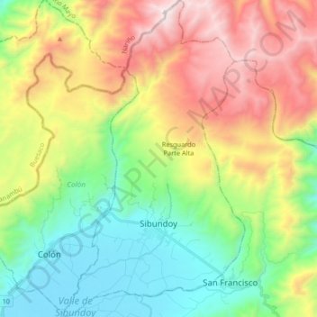
Name: Sibundoy topographic map, elevation, terrain.
Location: Sibundoy, Putumayo, 861020, Colombia (1.15703 -76.96561 1.30158 -76.87133)
Average elevation: 8,688 ft
Minimum elevation: 6,752 ft
Maximum elevation: 11,821 ft
Thank you for supporting this site ❤️
Make a donation
Make a donation
Gear up for your next adventure:
As an Amazon Associate, this site earns from qualifying purchases at no extra cost to you.
Other topographic maps
Click on a map to view its topography, its elevation and its terrain.
La Hormiga
Colombia > Putumayo > Valle del Guamuez (La Hormiga) > La Hormiga
Average elevation: 1,073 ft