
Make a donation
Gear up for your next adventure:
As an Amazon Associate, this site earns from qualifying purchases at no extra cost to you.
Hoosier Pass topographic map
Click on the map to display elevation.
Make a donation
Gear up for your next adventure:
As an Amazon Associate, this site earns from qualifying purchases at no extra cost to you.
Hoosier Pass
Hoosier Pass (elevation 11,542 ft (3,518 m)) is a high mountain pass in central Colorado, in the Rocky Mountains of the western United States. The name derives from Indiana, nicknamed the "Hoosier State," which was the original home of many pioneers.
Make a donation
Gear up for your next adventure:
As an Amazon Associate, this site earns from qualifying purchases at no extra cost to you.
About this map
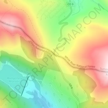
Name: Hoosier Pass topographic map, elevation, terrain.
Location: Hoosier Pass, Summit County, Colorado, United States (39.36183 -106.06268 39.36193 -106.06258)
Average elevation: 11,450 ft
Minimum elevation: 10,669 ft
Maximum elevation: 12,303 ft
Summit County trails, hiking, mountain biking, running and outdoor activities
Make a donation
Gear up for your next adventure:
As an Amazon Associate, this site earns from qualifying purchases at no extra cost to you.
Other topographic maps
Click on a map to view its topography, its elevation and its terrain.