
Make a donation
Gear up for your next adventure:
As an Amazon Associate, this site earns from qualifying purchases at no extra cost to you.
Heedfeld topographic map
Click on the map to display elevation.
Make a donation
Gear up for your next adventure:
As an Amazon Associate, this site earns from qualifying purchases at no extra cost to you.
Heedfeld
Albringwerde | Altenhorst | Altenhülscheid | Amphop | Berkey | Brake | Brinkerhof | Dahlerbrück (Ortsbereich östlich der Volme) | Dahlhausen | Davidshöhe | Dornbusch | Eichholz | Everinghausen | Everinghauser Heide | Felde | Flaßkamp | Gelstern | Golsberg | Grünenthal | Häuschen | Hardt | Harrenscheid | Haue | Hellhof | Heedfeld | Hilmecke | Holthausen | Horst | Hülscheid | Hütte | Kamp | Kämpershof | Klagebach | Klagebacher Hammer | Kragelohshammer | Kuhlenhagen | Kuhlenkeppig | Lauenscheid | Lauenscheidermühle | Lauenscheiderohl | Lindenteich | Linscheid | Linscheiderbecke | Linscheiderschule | Mesekendahl | Mesewinkel | Muhle | Muhlerhagen | Muhlerohl | Muhler Ölmühle | Mummeshohl | Neuenbrücke | Oberklagebach | Ölken (Ortsbereich östlich der Volme) | Ohlerberg | Ramsloh | Rehweg | Reineberge | Rölvede | Rölveder Mühle | Rosenhagen | Schalksmühle (Ortsbereich östlich der Volme) | Schalksmühlerhammer | Schleifkotten | Schlöten | Schmermbecke | Schnarüm | Siepen | Sonnenscheid | Spormecke | Stallhaus | Sterbecke | Sterbeckerhammer | Trimpops Walze | Twieströmen | Vormwald | Waldesruh | Wersbecke | Westhöhe | Wilfesche | Winkeln | Winklerheide | Worth
Make a donation
Gear up for your next adventure:
As an Amazon Associate, this site earns from qualifying purchases at no extra cost to you.
About this map
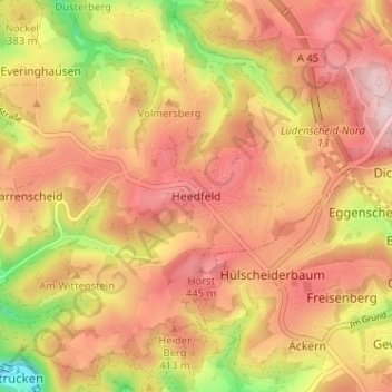
Name: Heedfeld topographic map, elevation, terrain.
Average elevation: 1,263 ft
Minimum elevation: 751 ft
Maximum elevation: 1,581 ft
Make a donation
Gear up for your next adventure:
As an Amazon Associate, this site earns from qualifying purchases at no extra cost to you.
Other topographic maps
Click on a map to view its topography, its elevation and its terrain.
Rölvedermühle
Deutschland > Nordrhein-Westfalen > Märkischer Kreis > Schalksmühle > Everinghausen
Average elevation: 1,175 ft
58579
Deutschland > Nordrhein-Westfalen > Märkischer Kreis > Schalksmühle > Harrenscheid > Davidshöhe
Average elevation: 1,148 ft