Geolocate

Mount Pink topographic map

Click on the map to display elevation.

About this map

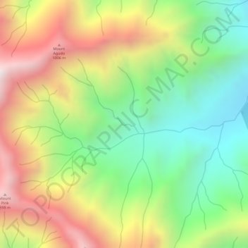
Name: Mount Pink topographic map, elevation, terrain.

Location: Mount Pink, Zambales, Central Luzon, Philippines (14.88606 120.12439 14.88616 120.12449)

Average elevation: 1,647 ft

Minimum elevation: 299 ft

Maximum elevation: 3,189 ft

Other topographic maps

Click on a map to view its topography, its elevation and its terrain.

Mapanuepe Lake

Philippines > Zambales > Aglao

Average elevation: 617 ft

Anawangin Cove

Philippines > Zambales

Average elevation: 197 ft

Acid Lake

Philippines > Zambales > Subic

Average elevation: 1,280 ft

Gear up for your next adventure:

Camping Coffee Makers - Enjoy premium coffee at the summit or campsite
🔥Fast-Boil Camping Stoves - Efficient cooking systems for quick trail meals
🛠️Outdoor Gear Repair Kit - Essential tools to fix gear on the trail
Solar GPS Watches - Advanced multisport watches with built-in topographic maps
🗻Climbing Gear Basics - Essential gear for beginner climbers

As an Amazon Associate, this site earns from qualifying purchases at no extra cost to you.