
Rybníček topographic map
Interactive map
Click on the map to display elevation.
About this map
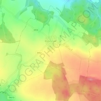
Name: Rybníček topographic map, elevation, terrain.
Location: Rybníček, okres Havlíčkův Brod, Kraj Vysočina, Czechia (49.75484 15.49435 49.77870 15.52933)
Average elevation: 1,588 ft
Minimum elevation: 1,417 ft
Maximum elevation: 1,745 ft
Other topographic maps
Click on a map to view its topography, its elevation and its terrain.
Velká Bíteš
Velká Bíteš, okres Žďár nad Sázavou, Kraj Vysočina, 595 01, Czechia
Average elevation: 1,621 ft