
Rocha topographic map
Interactive map
Click on the map to display elevation.
About this map
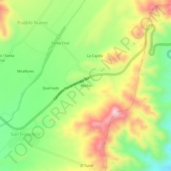
Name: Rocha topographic map, elevation, terrain.
Location: Rocha, Santa Cruz, Province of Palpa, Ica, Peru (-14.51346 -75.25964 -14.47346 -75.21964)
Average elevation: 1,880 ft
Minimum elevation: 1,260 ft
Maximum elevation: 2,651 ft
Other topographic maps
Click on a map to view its topography, its elevation and its terrain.
Chimba
Peru > Ica > Santa Cruz > Huayuri
Chimba, Huayuri, Santa Cruz, Province of Palpa, Ica, Peru
Average elevation: 1,558 ft